Welcome to the Midnight
Collective Broadsheet 126
Actively
supporting NZ’s endangered wetland birds
 |
At the height of this flood the Wharemauku creek (centre of foto) merged with these flooded areas
|
 |
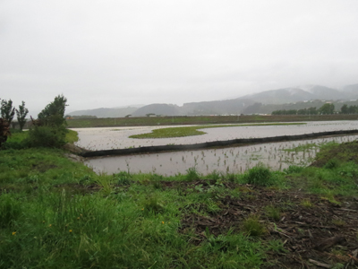
| Gentrification well underway as this western side begins to flood |
We are putting up a foto essay of a new large
flood that swamped the new around the M2PP Wharemauku Bridge site on November
15. This flood reached the same level as the September 4 flood and confirms
that this area will now be subject to major flooding events although, once
again, this was not a serious flooding event and would not have caused local evacuations in residential areas.
Around 85mm of rain was recorded in Raumati
Beach, though upwards of 140mm was reported from the local Tararua ranges. This
caused the Waikanae River 10 km to the north, to flood into surrounding
farmland.
One feature of both this and the previous flooding in early September has been the way in which the Wharemauku creek level maintained itself at bank-topping height over a 24 hour period and was still at around 60% capacity the next morning. We have had a very wet spring with two major flooding events. Over the past five years we might have seen one storm like this every two years. We have had two in the last three months.
No conclusions can be drawn of course, about the long term climate implications, although over time this level of flooding will build up silt in these flooded areas. While this creek can rise very quickly, it usually goes down just as fast. It peaks about an hour after the rain stops but in both these floods this didn’t happen.

Wharemauku Creek monitor 8.14am


Wharemauku
monitor 5.10pm at full flood. The flood
of May last year that caused evacuations downstream peaked a foot above this
monitor.

Flood water sucked out through drain into the
Wharemauku excavations.

Drain backfilling from Wharemauku, early
morning.

Flooding begins to inundate new plantings –east
of expressway 8.15am

Same eastern area inundated 5.10pm

Western area backfilling 7.45am Gentrification
around this area is well underway.

Flood peak in Western area at 5.15pm
Western area from the back looking north–
bridge in distance; centre left 8.15am

The Wharemauku walking track at peak flood downstream in
late afternoon sunlight. 5.15pm The major flood of last year peaked three feet
above this.
Though it is still very early days in the life
of this new area our next post will look at some of the changes that are
occurring to the animal and plant life of this area.
Track we were listening to while posting this –
Leader of the Pack from the Shangri-Las.
Mm--
"Is he really going out with him?
"Well, there he is, Let's ask him"
"Sam, is that the Trumpets ring you're wearing?"
"Mm-hm"
"Gee, it must be great riding him"
We are thinking of you all in the US of A; pondering as many of you no doubt are, the gerrymander of how someone who loses an election, actually wins. (It used to happen here before we brought in proportional representation). But then hoping you won't take it personally when it comes to the point of breaking off diplomatic relations. (Are they really trying to force the Brits to sack their ambassador? Will the Brits oblige?)
No comments:
Post a Comment